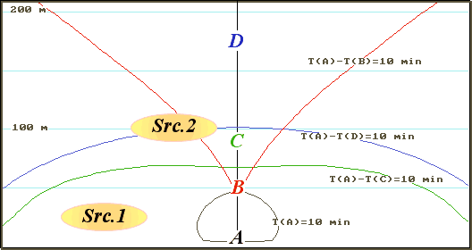
Fig. 1. 10-minute SBZ and HBZ for an item A and three variants of position of sea level stations (in points B, C and D). Ellipses Src1 and Src2 show two various positions of a source of a tsunami relative SBZ and HBZ
Alexander A. Poplavsky, Vasily N. Khramushin
Abstract: The methods of optimal planning for a sea level measurements station is described in composition of the tsunami warning system for Indian Ocean. The number and placements of sea stations were defining from condition for the effective timely of tsunami warnings. The proposal variants has optimal stations placement for a island Sumatra protection. Offered strategy can be use for the consequent tsunami warning revision, on a way from the initial seismic event thru direct tsunami observations. The special software is offer for the realizing of this strategy.
Anyone tsunami warning service (TWS) should include two subsystems of supervision (seismic and hydro physical), a data-processing centre and decision-making, a subsystem of communication and the tsunami warning. Really, TWS can represent as physically and legally independent system, and virtual, included other systems of monitoring, communication and the operative notification. In the latter case TWS it is organized on a signal of system of seismic monitoring and functions during the limited "disturbing" interval of time. From the point of view of economy of means for creation and operation this variant of the organization of new TWS in Indian ocean seems to the most preferable. In this case the basic efforts should be concentrated on creation of information infrastructure TWS both its algorithmic and program filling. In already existing systems of seismic and hydro physical monitoring, probably, minor alterations should be brought only.
The given work will consist of two parts. Its first part is devoted to a question on optimum accommodation of stations of measurement of a sea level in structure TWS of Indian ocean from the point of view of maximal use to the sea level information for specification of the forecast of a tsunami in development of the phenomenon. The received results allow to determine, how the existing system of hydro physical monitoring that it appeared the most useful to needs TWS should be added.
The second part is devoted to the description of the realized computer methods of specification of the initial (seismological) forecast of a tsunami according to the subsequent hydro physical monitoring.
In work the method of numerical modeling of kinematics and dynamics of distribution of a tsunami realized as the specialized complexes of programs is used.
In given article, with reference to basin of Indian ocean, ideas and the methods stated in works (Bernstein, 1992, Poplavsky at al, 1997) are used.
Utility TWS, first of all, is determined by its ability to start registration of a useful signal with the certain advancing concerning the moment of the earliest arrive of a wave to covered settlements (sites of coast).
Useful signal for a seismic subsystem of supervision - elastic disturbances in the firm ground, for a hydro physical subsystem - a wave of a tsunami.
The necessary minimal interval of an advancing of registration of event Δt the observant subsystems TWS, counted from the moment of the beginning of earthquake, develops of the following not crossed intervals of time:
If the actual advancing of registration of dangerous event in a seismic subsystem will be less necessary TWS cannot warn timeliness. There will be a fatal (inevitable) miss of a tsunami.
The similar adverse situation in a hydro physical subsystem will mean that supervision over a sea level cannot be used for the operative warning of a tsunami.
All above-stated sizes can and should be strictly determined, both for seismic, and for a hydro physical subsystem. Then the sizes of a necessary minimal advancing of registration will be determine: for seismic - D t(seismic) and hydro physical - D t(hydro) subsystems.
Let i = 1, 2, … I - names of covered items of coast and j = 1, 2, … J - names of stations of measurement of a level. Then the condition of timeliness of reception of the tsunami warning in item i from seismic subsystem of TWS will be T(i)> D t(seismic).
It means, that the duly warning will be received only with those items, a waiting time of tsunami T(i) (the propagation time of a tsunami from a concrete source up to item i) in which will be not less necessary time of an advancing of registration.
The similar condition for a hydro physical subsystem will be T(i) - T(j) > D t(hydro).
It means, that duly specification of the forecast of a tsunami will be received with those items i and from those stations j, the difference of waiting times of a tsunami in which will be not less necessary time of an advancing of registration.
The written above conditions have transparent geographical interpretation: if from item i to draw the (return) isochrones for the tsunami propagation time, equal waiting (expected) time D t(seismic), it will limit area of probable sources of a tsunami about which this item will not receive the timeliness warning from seismic subsystem TWS. We name this area seismic blind zone (SBZ). A tsunami from the real source crossing such zone, it will be missed by a seismic subsystem for item i.
Similarly, isochrones of the difference of waiting times of a tsunami in item i and on sea level station j, equal D t(hydro), will limit on water area hydro physical blind zone (HBZ). A tsunami from the real source crossing such zone, it will be missed sea level station j for item i.
Told illustrates fig 1 on which are represented SBZ and HBZ for item A and sea level stations established in points B, C and D in model basin with a flat inclined bottom. A minimal time of an advancing of registration D t(seismic) = D t(hydro) =10 minutes.
Fig. 1. 10-minute SBZ and HBZ for an item A and three variants
of position of sea level stations (in points B, C and D). Ellipses Src1 and Src2
show two various positions of a source of a tsunami relative SBZ and HBZ
Tsunami from source Src1 it will not be missed by a seismic subsystem as they are outside SBZ. The hydro physical subsystem as sea level stations, available in points B, C and D appears useless as this source is in limits HBZ for all three positions sea level station.
About a tsunami from source Src2 the item A will be timeliness warned as according to seismic, and hydrophysical subsystems if the sea level station will be established in a point C.
This figure illustrates also important extreme property HBZ. Dependence of the area of this zone on position of sea level station is no monotonic and also has a unique minimum, when sea level station is established on an axis of symmetry SBZ on distance in 2 times of the greater its diameter, irrespective of size of an inclination of a bottom. The relation of corresponding waiting times of a tsunami in item A and optimal point equal Ö 2. This property is used below at a choice of concrete places for the high sea level stations in real pools.
Actually the sizes which are included in conditions of timeliness, are not determined, or determined is rather inexact. On the basis of our own rough estimates we shall accept further, that D t(seismic) = D t(hydro) = 30 minutes.
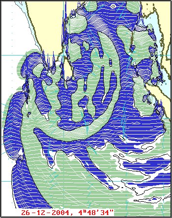
It is known, that the overwhelming majority of epicenters of earthquakes in Indian ocean concentrates near to coast of Indonesia in a strip in width up to 400 - 500 km, adjoining to islands. This area is the generator of a tsunami. It agrees (Gusyakov, 2004) with 1900 year on present time in it there were 20 earthquakes with the magnitude M ³ 7, 12 from which were accompanied by waves of a tsunami with intensity I ³ 0.
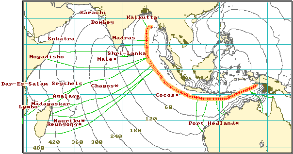
Fig 2. A map of the isochrone’s a propagation time of a
tsunami from the generalized source shown as a fat yellow - red line. Time is
specified in minutes. In the points, marked it is sign *, have available sea
level stations. Green lines mark separate rays of a tsunami. On the relative
sizes of sites of the generalized source and corresponding sites of coast,
between the neighboring rays, it is possible to judge prisoners qualitatively
height of the first wave at coast.
On fig 2 the map of the isochrones of a tsunami propagation time from the generalized source of a tsunami is shown. This source is limits the ocean area of the greatest concentration of epicenters. From this figure it is visible, that the most part of coast of Indian ocean has a sufficient stock of time for the decision on evacuation of the population from coastal line in case of occurrence of a tsunami at coast of Indonesia.
Corresponding calculations show, that the existing system of hydro physical supervision provides an advancing of registration of a tsunami more than 30 minutes relatively the earliest moment of the approach (arrival) of a wave to anyone peripheral (relatively Indonesia) to a site of coast.
In adverse position there is only ocean Indonesian coast.
The coasts adjoining to the generalized source of a tsunami are in the most adverse conditions as real tsunami can arise in any place of the water area borrowed with this source. It means, that the misses of a tsunami connected to infringement of conditions of timeliness – fatal misses are inevitable. However there is an opportunity to reduce of probability of such misses to a reasonable minimum.
It is known, that the relief of a bottom near to coast of real basins is very non-uniform: extensive zones of coastal shallow water are replaced by deep-water zones closely adjoining to coast. It is obvious, that the wave of a tsunami will reach the coastal feature nearest to a source all over again in points to which deep-water zones adjoin, and then will cross the next, extensive zones of shallowness.
The method of search of position of set of coastal points, which the tsunami wave always will reach most early is based on this property near coastal bottom relief. It will consist in the following.
In these points it is necessary to place stations of measurement of a level near to coast.
On fig 3 it is shown the map of regions of the responsibility of 153 points coasts of islands Sumatra and Java (allocated by little crosses).
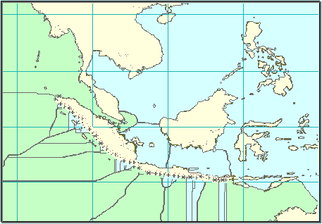
Fig 3. A map of region of the responsibility of 153 points of
coast of islands Sumatra and Java. Most extensive of them are separated by green
color.
11 most extensive are chosen from 153 regions of the responsibility. Points corresponding to them can be considered as a variant of the plan of arrangement coastal sea level stations. On fig 5, little crosses allocate them.
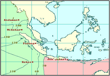
Fig 4. A map of isochrone’s of an advancing time of tsunami
registration on existing sea level stations relatively the moment of the tsunami
arrive to settlement Jakjakarta.
Then, for these points optimum sea points have been found. Installation sea level stations in the found sea points provides a minimum of the area 30-minute GBZ within the limits of region of the responsibility of a corresponding coastal point.
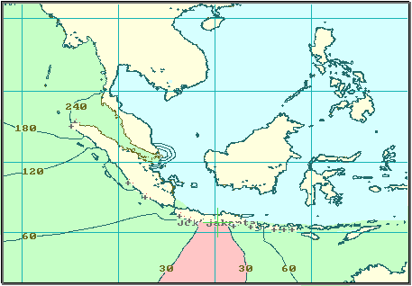
Fig 5. A map of isochrone’s of an advancing time of tsunami
registration on sea level stations in points “+” relatively the moment of the
tsunami arrive to settlement Jakjakarta.
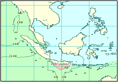
Fig 6. A map of isolines of an advancing time of tsunami registration on
sea level stations in points "*" relatively the moment of the tsunami arrive to
settlement Jakjakarta.
On a below-mentioned series of figures (4 - 6) they are shown the maps of isochrone’s of the advancing time of tsunami registration relatively settlement Jakyakarta (island Java) for three variants of disposition of sea level stations. On fig 4 we have the map of mentioned isochrone’s for existing near to Indonesia sea level stations (Andaman, Nicobar, Padang, Cocos). On fig 5 we have the same for disposition sea level stations in the points with most extensive responsibility regions. And on fig 6 we have the same for open sea level stations (points are marked as *). In these figures red color separates 30-minute hydro physical blind zones, and green color separates areas of an arrangement of probable sources of a tsunami, the warning about which will receive in Jakjakarta timeliness.
From this series of figures it is well visible, that the suggested new installation sites of sea level stations near to coast and the open sea appreciably improves opportunities of hydro physical subsystem TWS.
The arrangement of sea and coastal hydro physical stations optimized according to a developed technique provides the quickest registration of waves of the tsunami moving from the most probable places of underwater earthquakes. Thus it is guaranteed, that in the elected points of supervision the crest of the first introduction of a wave of a tsunami will be always less, than on protected sites of coast. The form of a wave in these points will reflect most precisely features of hydro dynamical processes in a seismic origin, tsunami resulted in occurrence. Therefore the operative information from the optimized hydro physical posts can be used as entry conditions for start of direct computing experiments on modeling moving to concrete sites of coast of a tsunami wave.
Rice 7. If the half-hour tsunami approaches to coast of India and
Sri Lanka the height of wave repeatedly amplify comparatively with waves of other
duration.
Within the TWS framework, up to the approach of a wave to covered coast, can be used three kinds of estimations, it is consecutive made more exactly the initial (seismic) forecast of a tsunami.
At once after an estimation of parameters of underwater earthquake cinematic maps of arrival times of the tsunami wave to various sites of coast pay off. The sites of coast where first wave will be most dangerous can determine. Then entry conditions prepare, and computing experiment is started according to height of a tsunami on covered coast with use of rough empirical models of the tsunami source (fig. 2).
After registration of a tsunami on any of hydro physical stations real parameters of a tsunami (for example, amplitude and duration of the first half wave) are determined. Computing experiments on modeling or a tsunami adapt for real conditions, or are started with new entry conditions (fig. 7). In result the specified estimations of expected heights of a tsunami at coast turn out.
At receipt of the information from several hydro physical posts, it can recalculate of hydro dynamical parameters of a tsunami which are used for the decision on prolongation or a cancellation of alarm of a tsunami (fig. 8).
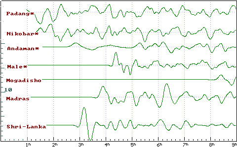
Fig. 8. Settlement records of a tsunami from the beginning of day
on December, 26, 2004. On the bottom scale time across Greenwich in hours is
shown.
The technique of optimization of the sea level station disposition can be applied with success at creation of national TWS in Indian ocean. Thus the system of hydro physical supervision can be used for the operative forecast not only a tsunami, but also other dangerous sea phenomena, such as storm surges.
The developed software allows to estimate and specify parameters of a tsunami in the rate outstripping development of the phenomenon. With this software it is possible to get acquainted and take in details program modules for practical use on a site www.science.sakhalin.ru.
Bernstein V.A. The problem about timeliness of alarms of a tsunami from one hydrophysical station in semi-infinite basin with a strip bottom. – Preprint. - Yuzhno-Sakhalinsk, 1992. - 50 p. Rus.
Gusjakov B. K. Integrated Tsunami Database for the Pacific and Eastern Indian Ocean. Version 5.12 of December 31, 2004.
The operative forecast of a tsunami for sea coast of the Far East of Russia / A.A. Poplavsky, V.N. Khramushin, K.I. Nepop, J.P. Korolev. – Yuzhno-Sakhalinsk, 1997. - 273 p. Rus.